(Overberg — written for BIKE SA in 2018)
As a tourist to the Cape, if you were eating lunch at the Two Oceans Restaurant at the southernmost promontory of the Cape Peninsula, you could be forgiven for thinking you were at the southern tip of Africa. But, like many early seafarers you would be wrong as there is much land south of Cape Point — some 4000 square kilometres of it.
The true southern tip of Africa lies at Cape Agulhas more than 55 km south of Cape Point and it forms the apex of a large isosceles triangle of windswept land with Hermanus on its western edge and Cape Infanta on its eastern extremity. This region, known as the southern Overberg, is often overlooked by motorists and adventure bikers who tend to shimmy up the better known West Coast routes, north into the Cederberg, Bushmanland or the Karoo and, of course, that all-time tourist favourite, the Garden Route.
In the mind-numbingly hot February we were experiencing, it dawned on me that skirting around the edges of this southern Overberg triangle would be a good idea, so I called up my old Overberg riding mate, Iain Buchholz (aka The Bearded One) and off we set.
The last time The Bearded One (TBO) and I rode together; things didn’t start too well. In a freak accident, which of course had nothing to do with the lengthy kuiering we’d done with Bacchus the night before, TBO hit a rock only 50 metres down the track, fell over and cut his leg so badly he was ordered not to ride for months afterwards. And, because he then had an operation to his gear-changing foot as well, we hadn’t ridden together for nearly two years.

Sticking to dirt tracks as much as possible, our plan was to head east from Caledon and make for Protem, Bredasdorp (a visit to the Shipwreck Museum was on the agenda), Arniston, Struisbaai, Cape Agulhas, Suiderstrand, Die Dam and then to overnight at Pearly Beach. The next day would see us going west to Gansbaai, Die Kelders, skirting Stanford and then heading back to our respective hometowns.
“Hey boet, careful of these submerged rocks in the road, you know what happened last time,” I jibed TBO as we turned onto our first bit of dirt track outside Caledon.
As expected, my remarks elicited a fusillade of helmet-muffled expletives and an unmistakable hand gesture; unfortunately not softened by the strictures of his riding glove.
It was good to be riding with Iain again. When we stopped at a T-Junction after completing that first bit of exhilarating Krige dirt track, he was smiling so widely I thought he might have had a toke or two of thinking man’s tobacco before he’d left home; but then I remembered he had given up Vitamin Green many years back and surmised it must be a natural high.
Crossing the R326 after the grain silos of Rietpoel, I decided to take us on a semi-circular detour to Klipdale which would see us travel a section of road I hadn’t ridden since my Napier days. As we rode past the blue-gum ringed farmsteads with flocks of spurwinged geese, blue cranes and sacred ibises dotted amid the dry-shorn wheat fields, I reminisced about my long-ago exodus from Johannesburg to Napier in 2001 and how the move had spawned a rebirth of my love for adventure riding. Starting to ride again after an absence of fifteen years in the saddle, it was the back roads of the Overberg and a smoky old PE250 named Perd that got me back into the groove again.
The dirt track from Protem, via the Vlakkloof road, to the T-Junction with the R319 is an absorbing adventure ride. Leaving the grain silos of Protem behind us we descended a hill and entered the pastoral wonderland of Klipbankkloof. It was filled with sheep and dotted with old farm buildings, their time-weathered patinas making them look like they’d been there since the Overberg was first settled by European farmers in the early 18th century.
The next 10 km produced a thin and often meandering farm track with dense bush on either side of it, the type that makes you suspect a steenbok or other suicidal critter may jump in front of you at any moment. But luckily, we got through unscathed and I felt energised by the demands of the track when we arrived at the tarred R319 a short while later.
The Bearded One, however, had pain in his post-op foot and he expressed the need to change the dressing and add more anaesthetising cream when we got to Bredasdorp. Even though the good folk at Superbike Solutions had made him a custom gear-shifter which would not hit the wound just behind his big toe, the vibrations and shaking on the rougher sections of the track were still causing him discomfort. But he soldiered on; it seemed like nothing short of a direct meteor strike was going to rain on his parade this time.
Apart from beautiful coastal villages, excellent wines from the southernmost vineyards in the Elim wine ward and a visit to the southern tip of Africa; shipwrecks feature strongly on tourists’ radars here. And that’s because, of the roughly 2500 shipwrecks recorded around South Africa’s coast around 150 of these occurred within 60 km either side of Cape Agulhas. In addition to strong currents, hidden reefs and rogue waves, early navigators noticed their compass needles behaved strangely in this region, showing a deviation of only 6 degrees (as opposed to the actual figure of 24 degrees) between Magnetic and True North. This large difference accounted for numerous navigation errors and consequent wrecks in the area and gave the Cape its name, Golfo de Agulhas — Portuguese for Gulf of Needles.
Even if you’re not that into shipwrecks, the atmospheric and stimulating displays and dioramas will definitely get your attention at the Bredasdorp Shipwreck Museum. In addition, there’s a recreation of a period-specific Strandveldhuis in the old parsonage next-door and a vintage coach house complete with many Cape carts and an old fire engine.
I got so carried away with all the nautical memorabilia, dramatic ships’ figureheads and tales of sunken treasure, I almost forgot my mission: to assign a wreck to each of the coastal town’s we were going to visit. In the end we settled on the HMS Arniston (May, 1815) wrecked near the town of the same name; the Queen of the Thames (March, 1871) which foundered off Struisbaai; the Johanna (1682) which sank off Cape Agulhas; the Jessie (July, 1829) wrecked near Quoin Point (close to Die Dam) and finally the well-known HMS Birkenhead (February, 1852) which came to grief off Danger Point near Gansbaai.
(For more detail, see the “Overberg Town’s and their shipwrecks” sidebar.)
All this historical stuff made us very hungry and we headed to the local Wimpy for brunch. Their new bowl breakfasts – we had the mince, egg, hash brown croquettes and cherry tomato combo — are a triumph and suitably reenergised we set off on the short stretch of tar to take in our first coastal village of the trip — one-of-a-kind Arniston.
Fringed by limpid, turquoise and aquamarine waters, sculpted putty-coloured rocks and white sand beaches, Arniston is a photographer’s paradise. Add to this, the vibrantly coloured fishing boats and equally colourful fisher folk, plus the quaint whitewashed and thatched roof houses of Kassiesbaai, and you have a must-visit destination.
“How much did that beautiful fish cost you?” I asked a man clasping a large yellowtail and trailing pungent liquor fumes in his wake.
“Jus wun hunnnerd runt; a bargain my broe; jy moet een vir jou koup,” he replied.
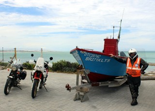
After taking the obligatory bikes and boats shot, The Bearded One and I continued to watch the sale of fish from one of the boats that had just come in. Yellowtail on the braai is a firm favourite of mine, but with no cool bag on the bikes and four hours to go until we reached Pearly Beach, we decided not to risk the fish spoiling and settled on buying boerie instead.
A short tour through the heritage site of Kassiesbaai (so-named because the early residents built their houses from the paraffin cases that washed up there) to the beach of the same name is a must. While there are two other good beaches in town, the gently sloping beach at Kassiesbaai is the prettiest in my eyes. Besides, it has a quaint outdoor restaurant from where you can take in the panoramic views over a meal.
We were glad to get off the tar just 6 km out of town. The 14 km dirt track shortcut to the tarred R 319 into Struisbaai and Cape Agulhas, although bone-shakingly hard, was a welcome reprieve from the boring blacktop which is unfortunately unavoidable if you want to access the towns on our route.
Deciding to give the picturesque Struisbaai harbour a miss this time (Pelican’s Restaurant is recommended as is the feeding of the ‘pet’ manta rays) we headed straight through the town and made for Cape Agulhas and then Suiderstrand just 6 km west of it.
If you are averse to ball-bearing type gravel and a few sandy patches here and there, it can be a challenging 6 km; but visiting this sleepy seaside resort is certainly worth the effort. A crescent shaped, kelp-filled bay surrounded by a sprinkling of predominantly wooden bungalows transports you back to a time before the coastal property feeding frenzy started in earnest. I focussed on one particularly dinky yellow and white pioneer-type shack and dreamed that ‘one day’ Annette and I would be able to put our feet up on its stoep.
From Suiderstrand, we needed to retrace our tracks through Cape Agulhas and Struisbaai, but we spiced up the return trip with a look-see at the only visible wreck along this coastline, the Japanese fishing vessel, Meisho Maru (1982); and also ticked off a visit to the cairn at the southernmost tip of Africa.
When we filled up the bikes at Struisbaai on our way back through the town, I noticed just how much thirstier Sir Galahad was than TBO’s Triumph scrambler. I was only getting about 15.7 km/l (mixed medium speed tar and dirt) whereas he was getting closer to 23 km/l, but I suppose the 46% difference is offset by the 15 year age difference between my bike and his. At least our greatly differing tank sizes (mine 25l and his 16l) gave us similar ranges.

At last we were on the dirt again. Although the surface is hard compacted clay, and is also very rutted in places, this dirt track to Elim is the only alternative to the tar and we soaked up the hammering as best we could. But once we reached the Wolvengat/Die Dam dirt track, the ride was more sumptuous and enjoyable.
Just a few kilometres into this trip, though, we came across Strandveld Vineyards and decided to taste some of their wares and possibly buy a bottle or two for our braai that night. Renowned for their Sauvignon Blanc (the pundits claim the terroir is similar to world-topping Marlborough in New Zealand); Shiraz and Pinot Noir, we tasted all three varietals and approved. But in the end we settled on an unlabelled Special Cuvee Pinot Noir at an ultra-special price (R35) and wished we were towing a Ventertjie so we could buy more.
Die Dam, so-named for the still waters in its reef-lined lagoon, is another all-time favourite coastal haunt for me. It was actually here where I’d tried to book our overnight stop at one of only two chalets for hire in the holiday resort and caravan park; but it seems they are booked out months in advance, so we had to settle for nearby Pearly Beach instead.
After manoeuvring our bikes out of the talcum-powder like sand we’d sunk into in our earlier enthusiasm to get close to the beach, we put the last few kilometres of sand and gravel under our tyres for the day and gapped it at high speed to Pearly Beach on the tar.
Our first impression of Pearly Beach resort, wherein our cute-looking cottage of the internet pages resided, was not overly favourable. The first thing the old security guard at the gate said to me was: “The last biker who stayed here was killed on the way home. A taxi pulled out in front of him when he was doing 280 km/h and his buddy got the whole thing on video; apparently there were bits of him lying everywhere.”
Apart from this gruesome tale, the whole place looked like a cross between an Ou oord from the 1950s and the Pleasantville set from the 1998 movie of the same name. The average cookie-cutter plot size is below 200 m2 and the tiny homes are cheek by jowl, crushed together against each other and the sand dunes like lemmings against a fence.
But first impressions can be misleading. After equipping ourselves with wood and other necessary braai requisites at the excellent local shop, we settled into our modest, but very comfortable quarters in Nautilus Street. With the fire blazing in the indoor braai and our recently acquired Pinot Noir flowing, any similarities to Pleasantville were soon forgotten.
The next morning I took a walk on the beach. TBO’s foot was still taking strain so I went alone and hustled most of the cobwebs out of my brain by virtue of a masochistic pace through the soft sands. On my route, sand pipers, black oystercatchers and seagulls scattered ahead of me as I strode towards Bantamsklip in the distance.
A cross perched high on a hummocky dune made me think of the many shipwreck survivors who’d trudged these sands in search of farmhouses in the distance. Many of them eventually made their way back to Cape Town; but a significant number stayed put and added a cosmopolitan flavour and flare to the Overberg coastline.
On my return through the resort village, I was greeted by many friendly people and realising that the residents here were content with their place in the sun and near the beach, I chastened myself for my assumptions of the day before. Perhaps I just need a little bit more elbow room than most.
Our plan for the day was to dawdle back to our respective homes, via the tarred coastal road to Gansbaai and De Kelders, and then to take the dirt track past Grootbos Private Nature Reserve to the often challenging Uilkraalsrivier road, then onto the Sandy’s Glen dirt track and head our respective ways home after brunch at Van Brakel’s Stoor on the R316.
Strictly speaking, we should have included Stanford and Hermanus on our travels as both these towns lie south of Cape Point, but we axed them on the basis they were both on busy tar routes, too full of people, and also because, strangely, I could find no shipwrecks recorded on my maps of the Hermanus area.
Before we got onto the main drag out of Pearly Beach towards Gansbaai, I asked TBO if he’d like to dice me to 120 km/h and he agreed. As soon as he’d nodded his approval, the wily coyote twisted the throttle like his life depended on it and got the drop on me. Yet, once Sir Galahad got his boilers up to temperature, I flew past him; but, of course, he said he’d reached 120 km/h already and had already decelerated while my GPS reading had only clocked 108 km/h when I passed him. Hmmmmm…rematch, I say!
Gansbaai Harbour is not the most picturesque; but it does have a good fish shop and a reasonable restaurant. TBO and I watched as a Shark Cage diving boat was refitted on the slipway and it gave me pause to think what a lucrative business it’s become over the years. Personally, I don’t believe chumming (attracting Great White sharks by trailing bait) should be allowed as it, as the Endangered Wildlife Trust advocate, can, inter alia “…trigger an indiscriminate feeding response in sharks without providing any nutritional return.”
After a quick stop at a view-site at De Kelders, an excellent site for whale watching in season, we made for the Grootbos dirt track. The first few kilometres are badly corrugated and lashed with sand in places, but your concentration is rewarded with superb mountain views when you crest the pass’s summit and look down on the heavily wooded slopes of the Uilkraalsrivier Valley.
A well-used dirt track, the Uilkraalsrivier road is rutted, full of twists and has numerous patches of fine gravel-ground sand that are prone to catch one out as they are often shrouded in shade. But it’s this shade and the pine and oak trees that provide it that make this variable road a welcome adrenalin booster. The cobwebs were now well and truly gone.
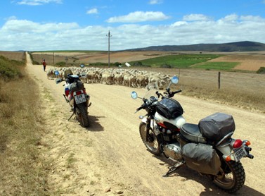
Coming onto the Sandy’s Glen road our progress was halted by a large herd of sheep. There was nothing for it but to get off the bikes, have a cool drink and watch the wave of recently shorn creatures wash past us. The Sandy’s Glen dirt track, with its long mountain pass, which winds its way up and between some serious Overberg mountains, is another favourite from my Napier days and I gunned it over the loose gravel; lost in nostalgic reverie.
Following a light lunch and an excellent pot of coffee at Van Brakel’s Stoor, the Bearded One and I did our last 14 km of dirt track together — a fast-paced up hill and down dale ride over the Overberg Rûens — before parting ways at the Tesselaarsdal turn-off.
Overberg towns and their shipwrecks
Arniston: Named after the HMS Arniston, a mixed passenger and cargo ship which came to grief on the Agulhas Reef on 31 May, 1815 after battling a storm and becoming separated from the convoy in which it was travelling. 372 People died, of which a 100 were wounded British soldiers returning from the Kandyar War in Ceylon. Only six made it to the shore.
Struisbaai: The Queen of the Thames, a blend of sail and steam technology, was said to be one of the fastest ships of its time. But a so-called navigational error (the Captain claimed a bushfire near Struys Point was mistaken for the Agulhas Lighthouse) caused the ship to be wrecked on 18 March, 1871. Some reports, however, claimed the weather on the night of the tragedy was perfect and that a St Patrick’s Day party was on the go when the ship struck the reef, fuelling rumours that gross negligence was the reason for the disaster.
Cape Agulhas: The Johanna, a 550-ton English East Indiaman on its way to Bengal in India, hit the reef just west of Cape Agulhas in the early morning of 29 May, 1682. Convinced he was too far south for land to lie in his path, the Captain ignored a warning from one of his crew who claimed to have seen land off the weather bow and soon after the vessel was aground. Some of her £72,000 cargo of bullion and silver coins was recovered at the time and some more in 1982. Of the 114 passengers and crew, 10 lost their lives.
Die Dam: The British vessel Jessie, after which the beautiful little bay between Quoin Point and Buffeljagsbaai is named, sank west of Die Dam on 10 July, 1829. Apparently the survivors got to shore on two of the ship’s boats and were assisted by the people of Elim while the remains of the ship and its cargo was guarded by local farmers. Gansbaai: HMS Birkenhead, the British troopship from which the quintessentially gallant saying “Women and children first” emanates, went down off Danger Point near Gansbaai on 26 February, 1852. Propelled by a combination of sail and steam power, this vessel hit a submerged rock around 2 a.m. and with the ship sinking quickly, and too few lifeboats to hand, the famous order to “Stand Fast” was given to the soldiers on deck while the civilians were loaded into the boats. 445 men died and 193 people survived.
The route and travel notes:
Day 1: Bot River to Pearly Beach: via N2 to Caledon; Rietpoel; Protem ; Vlakkloof; Bredasdorp; Arniston; Struisbaai, Cape Agulhas, Suiderstrand, Cape Agulhas, Struisbaai and Die Dam: Distance Day 1: 325 km, about 55% (171 km) on dirt tracks
Day 2: Pearly Beach to Bot River: via Gansbaai; Die Kelders; Grootbos Private Nature Reserve road; Uilkraalsrivier road; Sandy’s Glen, the R316; Van Brakel’s Stoor; the Tesselaarsdal-Caledon dirt track and the N2 to Bot River. Distance Day 2: Around 182 km, about 44% (80 km) on dirt tracks.
Total distance travelled: Around 507 km over 2 days riding— about 50% on dirt roads.
Experience required: Beginner (but just watch for the few sandy patches).
Best time of year to go: August to April
Route highlights: Protem via Vlaakkloof dirt track to R319 junction; Wolvengat dirt track to Die Dam, the Uilkraalsrivier road and the Sandy’s Glen dirt track.
What it cost us: Accom: R600 ea. Food, petrol, snacks, museum etc.: R750 ea. Total: R1, 350
Accommodation notes: Ons Strandhuisie, Pearly Beach Resort. Annelene: 083 690 6168