Part 1 — Bot River to Modderrivier
(Karoo and Northern Cape — written for BIKE SA in 2019)
Having visited the Northern Cape’s Second Boer War battlefields with my late stepfather, Harvey Tyson, some years back, I thought it a fitting tribute to him on the anniversary of his death, to not only re-enact the original journey but also to add to it by visiting some of the battlefields and monuments we hadn’t got to. Besides, it was the 120th anniversary of the start of the Second Boer War, another reason to revisit this landmark event in SA’s history.
Luckily, I was able to persuade my old friend, recent Bot River ‘inkommer’, Bruce Houghting, (ex-Hilton in KZN, rides a BMW GS1200 LC called Jabulani) to join me on this historic quest. It was the first section of a three-part journey over 8 days and 3061 kilometres, the second and third of which (The Lesotho and Mossel Bay Tours) will feature in upcoming issues.
I smiled as I thumbed the starter button and the KLR took immediately, its throaty roar quickly settling into a steady, tympanic beat. My maestro mechanic, AJ, from Hermanus Motorcycles, had done it again. He’d quickly put his finger on the bike’s hesitant starting problem of late (apparently two of the valve clearances needed adjusting) and fixed it.
Not having done much long distance adventure riding with Bruce, I used the first 50 kilometres or so to see what speeds he was comfortable with on tar and dirt and adjusted my preferences accordingly. By the time we got to the silos at Protem we’d settled into a comfortable compromise that sat pretty well with both of us for the rest of the journey.
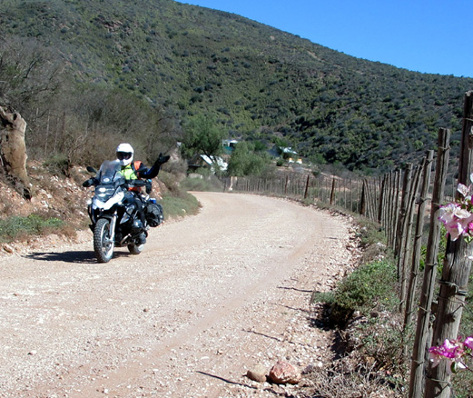
Our 435 km route plan to our overnight stop at Klaarstroom guest house incorporated about 60/40 tar/gravel and was to take in the towns of Swellendam, Barrydale, Calitzdorp and De Rust. And it was the Groenfontein dirt track towards Swartberg Pass and the Oude Muragie gravel road to De Rust that were the hands-down adventure riding favourites of the day.
After some really good coffee and superb milk tartlets at the Beans about Coffee shop at the new Caltex garage in De Rust, we were suitably fortified for the last 25 km to Klaarstroom. The rolling strata of Meiringspoort welcomed us into their loquacious embrace, their once molten facades speaking volumes of their geomorphological origins.
The sun was close to setting as we climbed a small koppie on the outskirts of Klaarstroom, some young tikes from the neighbouring township following us up the hill and pestering us to sit on the bikes when we went down again. Their day seemed to be made when we let them each twist the throttles of the bikes, wide open — the KLR’s Air Age roar getting the most favourable reaction.
The next day saw us on the blacktop at around 9 am, heading due north on the N12 towards Beaufort West. I was looking forward to the first dirt track of the day — 63 km of the Great Karoo’s finest gravel to Rietbron. It’s a road I’ve not travelled for some time but is one which brings back memories of the times I travelled these roads from Aberdeen to visit my late cousin, Richard. He’d holed up in a small cottage there, in the midst of this sandy inland sea, bounded by the incredibly distant mountain ranges we now saw on the four points of the compass: the Camdeboo range to the north, the Nuweveldberge in the west, the Swartberge to the south and the Kouga range in the east.
Comfortably secure in the grip of my Tractionator tyres I quickly settled into Zen-dirt tracking mode and recalled an ode to the Karoo penned by Harvey in his book, Have Wings Will Fly (Editor’s Inc. 1998): “The Karoo has stood motionless for millennia…Yet, within that vast stillness you become aware of the smaller paradoxes it offers you, and of their constant movement…Every hour, the Karoo changes colour; from the red of the dawn to a grey-green-yellow botanical carpet in the slanting sun; to the white heat of noon, to the blue pencil-lines of hills in front of a developing sunset. All this against a background of black stones and toasted brown earth, curling at the edges…”
My reverie was broken by a small herd of female kudu which materialised from behind a copse of acacia trees on the side of the road. Their graceful loping across the track and easy clearing of the metre-high fences was beautiful to watch. This out-of-nowhere miracle reminds one of another identifying characteristic of the Karoo — just when you think it’s devoid of life it surprises you with alacritous abundance. As I’ve said before, it’s our largest ‘national park’ and its irreplaceable environmental value needs to be protected at all costs.
“Joh, boet, thought I better stop and point out this well camouflaged aardvark hole to you, don’t want you getting lost in middle earth somewhere,” I said to Bruce on the stony, and sometimes loamy, dirt track from Rietbron to the R61 between Beaufort West and Aberdeen. The latter blacktop was a bridge to our next dirt track to Murraysburg, an engaging and scenic route which introduces the adventure rider to the first of many of the magnificent organ pipe-silled flat-topped mountains of the Eastern Cape.
After a quick fuel and coke stop in the once picturesque, but now sadly decaying town of Murraysburg, we gapped it onto the Richmond dirt track. It’s another absorbing Karoo dirt track, but much of it is lined with bush and acacia trees, and this fauna-cloaking vegetation checked our speed a bit. Since colliding and killing a steenbok a few trips back, I’m more aware than ever of unguided faunal missiles trying to unseat me.
Up ahead, one of the grand patriarchs of the Karoo was trying to cross the road. The Mountain (aka Leopard Tortoise) Tortoise in front of me was a fine example of this largest of SA tortoise species. It was about 500 mm in length and when I picked it up to help it cross the road, I estimated its weight to be around 25 kg. They can live up to a hundred years old in the wild and some giant specimens weigh close to 40 kg.
But, besides their armoured shell, it’s probably their dogged determination and stubbornness that’s ensured they have survived for millions of years. Doyen of the Karoo tale, Eve Palmer (The Plains of Camdeboo, Jonathan Ball, 1990), relays a relevant anecdote: “One October Sita and a group of visitors were picnicking in the lands when a great tortoise came trundling towards them through the wheat along a track which it had worn quite flat. They were obviously sitting in its usual line of march and waited to see what it would do. It looked belligerently at them but never hesitated, marching on with that swimming motion slap through the middle of the picnickers, upsetting the plates as it marched.”
The first evidence of the Second Boer War greeted us atop a hill in Richmond. Unfortunately the remnants of the British fort that repulsed two Boer attacks on Flag Hill (aka Vegkop), headed by Commandant Wynand Malan (he, JBM Hertzog, PC Kritzinger, JC Lotter and WD Fouché were on a mission to disrupt enemy lines and harass the British wherever possible) is on private property and not open to general public, so we didn’t get to see it close-up.
My initial plans had been to bypass Hanover and take the north-east heading dirt track out of Richmond, cross the N10 about 29 km west of Hanover and then to intersect with the tarred R389 some 16 km out of Phillipstown, our penultimate objective for the day. But, my penchant for trying to cram too much into one day, saw us faced with a dilemma — if we didn’t go through Hanover the bottle store in Phillipstown would likely be closed by the time we got there. And with a braai planned at our overnight guest farm, Rooipoort, the need for cold beer was paramount so I hastily drafted a compromise route.
In places the dirt track to Hanover is a smooth and wide affair, allowing higher speeds and more beer-saving miles to be ridden in less time. But, in my haste to get to the bottle store before closing time, I lost Bruce. It was only when I stopped to warn him of the danger of two amorous steenbok necking in a thorn bush that I realised he was no longer behind me.
I eventually found him some 5 km back, rolling along at a sedate pace — he’d stopped at a junction, not sure if I’d continued straight or turned left, until a farmer confirmed he’d seen me heading in the former direction. Clearly I’d not explained well enough that I’d never deviate from a route without waiting for him; but it was a lesson well learnt for the rest of the trip.
“I keep thinking there’s somebody outside our front door,” I remarked to Bruce as we cracked our first cold one around the braai fire.
Kay Fourie, wife of Rooipoort farmer and successful businessman, Andries, is an accomplished sculptor and painter. And it was one of her life-sized figures, standing sentry near the front door, which startled me every time I saw it’s neatly coiffed cement hairdo through the kitchen window. But it takes more than the odd spooky sculpture to put Bruce and me off our food and drink, and we continued to beat a regular path to the fridge.
After a short walk around the Fourie’s historic property (it’s been in the family for about 190 years — apparently trek leader Andries Pretorius passed by here) appraising their magnificent Georgian-styled home, the collection of sculptures in the garden and being bleated at by some uber-cute new-born lambs, Bruce and I hit the dirt track to Petrusville.
It was a rude awakening. Andries had said it was “about 30km”, but it turned out to be more like 40 km of bone-jarring stone, ruts, loose shale and sand. But it certainly shook the cobwebs out of our heads and helped us work off the excellent meat, ‘papdis’ and salad (see amazing biker-only offer under accommodation in sidebar) we’d consumed the night before. By the time we stopped in town to refuel the bikes we were sweating bullets.
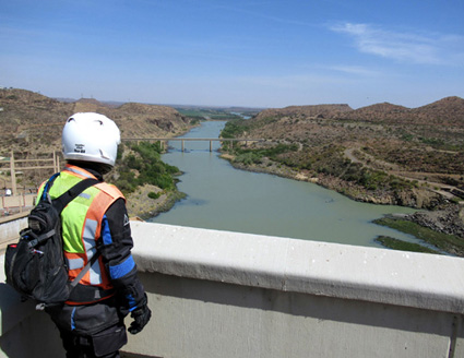
Only 20 km out of town, though, we were soon fanned by a cool breeze coming off the silver sheet of water contained by the impressive Vanderkloof Dam wall, which, at 108 metres, is the highest in the country. Had we not needed to make tracks it would’ve been entertaining to have cast a long line among the many yellowfish feeding at the bottom of the wall near the sluices, but of course that’s best done with a fly rod from the bank or a boat.
Like many of the small Karoo towns I first came to know on my first major journey through these arid reaches in 2005, Luckhoff’s previously quaint appearance and clean streets are no more. The burgeoning local populace, despite very frank signboards pleading for contrary behaviour, seem hell-bent on turning the place into a trash heap. The last town to get gas streetlights at the turn of the 20th century may now well be the last place people are likely to want to live in, visit, or invest in, too.
Koffiefontein, the next town along the tarred R48, was a bit cleaner but not much more tourist friendly. Following a few monument signs we went around in circles until we saw what looked like a canon atop a distant hill; yet it was inaccessibly situated beyond the modern-day diamond mining compound. Having found neither Boer war relics nor remnants of the Second World War POW camp (eight hundred pro-Nazi South Africans, including BJ Vorster, were also jailed here) we settled for inspecting an old steam tractor on display at the entrance of the town and took a photo at the now tired-looking coffee pot fountain which harks back to the days when the town was a popular coffee stop for transport riders.
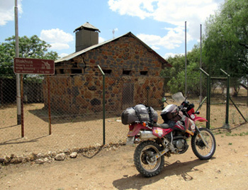
It was in Jacobsdal that Bruce and I finally got up close and personal with our first Second Boer War relic, a small and unusual-looking blockhouse on the north-eastern edge of town. Particularly dof that day, I first cruised right past it and it was only after about 5 km on a radically corrugated dirt track heading out of town, that I decided we must have missed it. In my addled brain’s defence, it was unusually small and sandwiched in-between two industrial sites. Although I have little sympathy for the British cause, I did feel a smidgeon of empathy for the hapless Tommies having to live under a non-insulated tin roof in these hot climes.
On the way to Jacobsdal from Koffiefontein, Bruce and I had seen a sign announcing: “43 km to Petrusburg”. The irony of us being so close to our overnight stop at that stage wasn’t lost on us, but all thoughts of an early arrival and an afternoon kip were extinguished as we headed due west in our quest to link up with the battlefield route Lord Methuen, later relieved by Lord Roberts, marched from Orange River Station (just east of Hopetown) towards Kimberley in the hope of relieving the siege the Boers had it under.
While Methuen’s initial northward push was punctuated by two major battles with the Boers at Belmont and Graspan, our route was to only intersect with the third major battle along the way, the one which took place along the Modder and Riet Rivers, but which is known as the Battle of Modderrivier (see sidebar for all battle details).
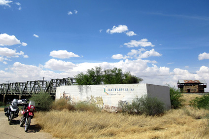
After Bruce and I walked around one of the epicentres of this battle — the area between the railway bridge and the confluence of the Modder and Riet Rivers just to the east — it was time for a snack and a drink. Ahead of this fierce battle, where General De La Rey’s eldest son, Adriaan, was killed and Methuen wounded in the thigh, the Boers had blown up the railway bridge and the well-preserved blockhouse seen there today was to protect the reconstructed one — built hurriedly by the Royal Engineers — from a similar fate.
How more British soldiers were not killed, as they marched downhill into a *“withering fire” from the Boers who were dug in for almost 7 km along the river banks, is a miracle.
*(courtesy SA military history website)
But we still had much ground and a number of battlefields to cover that day, not least of which was Magersfontein, the site of an immense Boer triumph and devastating British losses. A monumental battle that not only cost Lord Methuen his job, but which also taught the British they’d totally underestimated the resolve and battleground acumen of the Boers.
To be continued in the next issue
Northern Cape (Second) Boer War — main battlefield facts and stats
- Belmont: On 23 November, 1899, Methuen’s 8,000 soldiers faced up against 2, 300 Boers under General Prinsloo in the koppies and ridges east of Belmont Station. After a “soldier’s battle” that lasted about six hours, the Boers were driven off. British losses — killed: 54; wounded: 243. Boer losses — killed: 16; wounded: 30 and taken prisoner: 36. Although there’s little info here, it’s a good battlefield to walk as there is still evidence, in the form of billy cans etc. of the British army’s passing
- Graspan: 25 November, 1899, saw a strengthened Boer force in the hills between Graspan and Enslin sidings meet Methuen’s army. After heavy bombardment by British artillery, the infantry advance was ordered; but it was the Naval Brigade who successfully stormed the Boer’s main stronghold and who lost almost half their number to injury or death in the process. British losses — killed: 18; wounded: 143.
Boer losses — killed: 19; wounded: 41 and taken prisoner: 43.
- Modderrivier: By the morning of 28 November, 1899, the combined commandos
(3000+ men) of Prinsloo, De La Rey and Cronjé had dug themselves into the muddy banks of the Modder and Riet Rivers on either side of the railway line. Although Methuen’s main force was pinned down for most of the day, it was eventually the Boer’s right flank that gave way at Rosmead (Ritchie) and precipitated their retreat to Magersfontein that night. British losses — killed: 71; wounded/missing: around 407. Boer losses — killed: 50; wounded: approx. 30 and taken prisoner: 25.
- Suggested reading and useful links: Signage and battlefield info is scarce, so best read up ahead of the time — The Boer War by Thomas Pakenham; The Great Boer War by Arthur Conan Doyle and www.sahistory.org.za and www.angloboerwar.com